Allansford Flood Study
Council is undertaking flood modelling of the Hopkins River catchment at Allansford.
The investigation will look at risks posed by large riverine floods and changes brought about by climate change.
New information about climate change-induced extreme weather will enable more effective planning for Allansford.
Ultimately, the investigation will result in a Planning Scheme amendment that will include revised flood mapping and land use controls.
The investigation will also inform emergency response planning and build community flood resilience.
This project is a partnership with the Glenelg-Hopkins Catchment Management Authority with technical work carried out by Water Technology.
The community has contributed to the project by providing historical flood information that has helped calibrate modelling for the flood investigation.
A review of the flood data used to produce the flood model is available here.
The 1% Annual Exceedance Probably (AEP) or 1-in-100 Year Average Recurrence Interval (ARI) flood depth map for Allansford is available here.
A community meeting was held at the Allansford Mechanics Institute Hall on February 13, 5.30pm which discuss the flood depth mapping including:
- a summary of the project so far;
- project components still in progress including the Stormwater Management Strategy;
- the use of planning controls (overlays) to mitigate future flood risk;
- discussion and call for suggestions to mitigate Allansford's flood risk;
- relationship between this study and the Allansford Strategic Framework Plan;
- viewing of the flood mapping outputs from the study so far; and,
- an opportunity to ask questions.
You can watch a vide of the meeting here.
Keen to know more? Please get in touch.
Email: planning@warrnambool.vic.gov.au
Tel: 5559 4800
In person: Civic Centre, 25 Liebig Street, Warrnambool
Post: PO Box 198, Warrnambool 3280
If you have specific questions, concerns or comments please contact Peter Reid on 5559 4800 or preid@warrnambool.vic.gov.au
Bushfield-Woodford Strategic Framework Plan
Warrnambool City Council is developing the very first Strategic Framework Plan for Bushfield and Woodford, to be known as the Bushfield-Woodford Strategic Framework Plan (the Plan).
The two small towns of Bushfield and Woodford are situated in very close proximity to each other stretching from the Hopkins Highway in the east towards Caramut Road in the west; and approximately three kilometres from the City of Warrnambool.
The adjacent settlements face further residential growth and wastewater management challenges. Council needs to address these challenges while also protecting the unique features of these small townships to ensure great futures and unique rural lifestyle. The Plan aims to provide a coordinated, long term vision to guide land use and development and manage the future development of the settlements 20 years into the future.
Community participation is essential to achieving these objectives. An online community survey conducted late in 2022, a community drop-in session in March 2023 and engagement with a variety of government and community group stakeholders have guided the creation of a draft Plan. In September of 2023 Warrnambool City Council released the Draft Plan for public comment.
The community have provided significant feedback on the Draft Plan, both positive and negative. The comments have offered further thoughts and reinforced some priorities. There was great feedback on the Draft received from individual community members, community groups and government agencies with an interest in the small towns. The Draft Plan is currently being revised based on the feedback received, as expected. Some additional community engagement will take place prior to preparing the final version of the Plan.
A newly created Implementation Strategy will guide the further realisation of the revised Strategic Framework Plan vision and development over the next 20 years and beyond. Both of these will be presented to Council for formal adoption. The Implementation Strategy will also detail further technical work as well as actions required to realise the vision of the Bushfield-Woodford Strategic Framework Plan.
Development of the Plan is funded through a grant provided by the Victorian Planning Authority.
If you have questions or comments regarding the project, please contact Peter Reid on 5559-4800 or via email at preid@warrnambool.vic.gov.au. You can also write to:
Warrnambool City Council Strategic Planning
PO Box 198
Warrnambool, Vic, 3280
Warrnambool Open Space Project
Council is progressing an Open Space Project that includes:
- A review and update of the Warrnambool Open Space Strategy (2014) to provide a public open space planning framework to 2041. The Warrnambool Open Space Strategy 2026 - 2041 was adopted by Council 1 June 2026 and can be viewed on the Strategic Plans webpage
- Preparation of an Open Space Contributions Policy. This will open for feedback in June/July 2026.
- Preparation of associated planning scheme documentation for the Warrnambool Planning Scheme.
Background
Over the past decade, public open space planning has been guided by the Warrnambool Open Space Strategy 2014 (OSS). It is a reference document in the Warrnambool Planning Scheme. The purpose of the OSS is to provide an open space planning framework for Warrnambool to 2026.
The Vision of the OSS is for Warrnambool to have a high quality, diverse, accessible open space network that reflects community needs and enhances social connection, environmental protection and economic benefit. It adopted seven guiding principles: accessible, adaptable, connected, efficient, diverse, equitable, and protective of the environment. The OSS considered the provision of open space in Warrnambool to be good overall with connectivity between open space identified as a key gap.
With the 2014 OSS approaching end-of-life, it is time to review and update the OSS. With considerable population growth forecast for Warrnambool, it is important to understand future demand on the open space network and to identify further gaps in provision. An updated OSS is also important to enable the development of an Open Space Contributions Policy for inclusion in the Warrnambool Planning Scheme.
Warrnambool Council has used a range of mechanisms to collect open space contributions in the past, including Development Contribution Plans, legal agreements, and through the planning permit and subdivision process. Most contributions are collected under the Subdivision Act 1988, which must be assessed on a case-by-case basis and are open to appeal. Council would benefit from a more consistent approach, including setting fixed rates in the schedule to Clause 53.01 in the Warrnambool Planning Scheme.
It is expected that the Warrnambool Open Space project will deliver the following benefits:
• A contemporary open space strategy for the municipality to guide decision making about the future provision of, and broad improvements to, public open space.
• Outputs to enable financial resource planning and asset provision.
• Facilitate a coordinated approach to open space planning.
• Justification for the introduction of an Open Space Contributions Policy into the Warrnambool Planning Scheme.
• Clarity for landowners and developers about future open space contribution requirements.
• Clarity for the community about the future provision and improvement of open space.
• Reduce potential conflict between developers and Council about future contributions requirements (and potentially VCAT applications).
Council adopted the Warrnambool Open Space Strategy 2026 - 41 in June 2026 and the Open Space Contributions Policy has been prepared and will undergo public consultation during June/July 2026, before being exhibited and as a draft Planning Scheme amendment.
Council has engaged SGS Economics and Planning to undertake the Warrnambool Open Space Project.
For more information contact Open Space Planner Amy Cumming on 5559 4800 or acumming@warrnambool.vic.gov.au
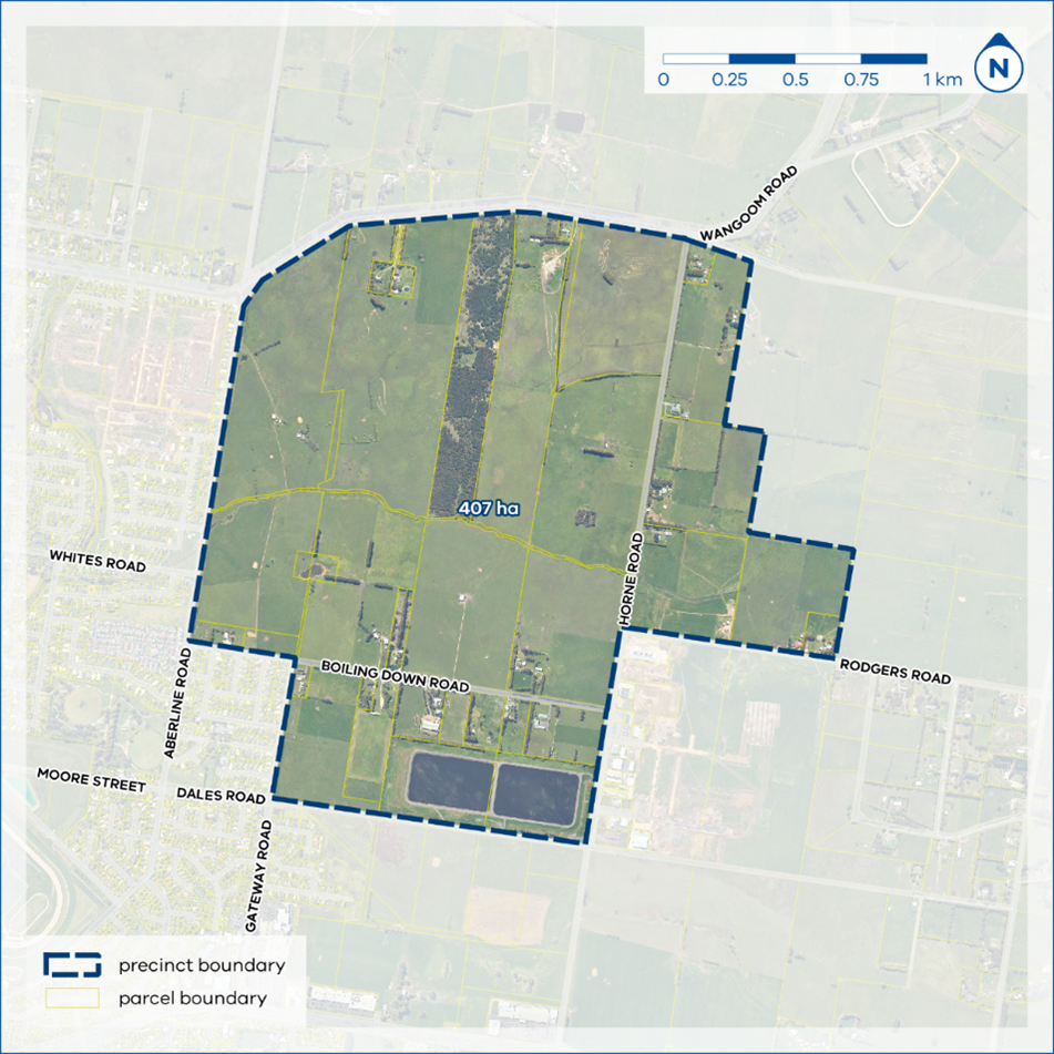
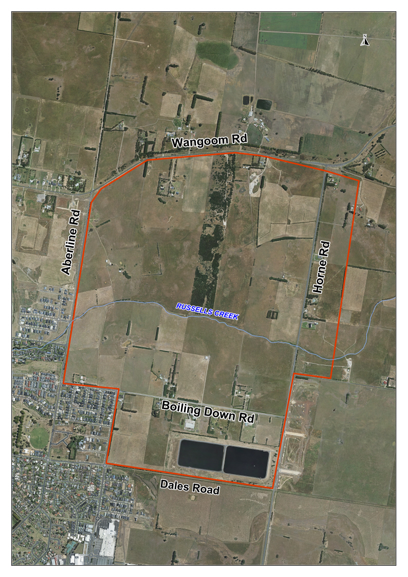
East of Aberline Precinct Structure Plan
The Victorian Planning Authority (VPA) in partnership with Warrnambool City Council (WCC) has prepared a precinct structure plan (PSP) for the East of Aberline precinct.
A PSP is a land use and infrastructure plan which guides the development of an area over time. It provides certainty for community members by providing a long-term vision for how an area will develop in the future.
The East of Aberline precinct is included in the Warrnambool City-wide Housing Strategy (2013) and the Warrnambool Planning Scheme which sets a strategy for long term development of Warrnambool.
The future urban growth area is located between Wangoom Road to the north, Dales Road to the south, Aberline Road to the west, and Horne Road to the east. The growth area covers approximately 407 hectares of land. The northern boundary of the growth area abuts the municipal boundary of Moyne Shire. The growth area is positioned centrally to other key development sites identified in the Warrnambool Planning Scheme, being the Eastern Activity Precinct and the Horne Road Industrial Precinct.
On 7 September 2019 the Minister for Planning appointed the VPA as the planning authority to prepare the PSP, at the request of Warrnambool City Council. This means that this project has been identified as a priority for timely completion by the Victorian Government and the VPA will lead the preparation of the PSP, working closely with Council.
In summary, the East of Aberline PSP:
• Sets out plans to guide the delivery of quality urban environments in accordance with the Precinct Structure Planning Guidelines: New Communities in Victoria, October 2021 (the PSP Guidelines) and the associated Guidance Note: Applying the PSP Guidelines in regional areas (Regional PSP Guidelines).
• Enables the transition of non-urban land to urban land.
• Sets the vision for how the land should be developed and the outcomes to be achieved.
• Outlines the infrastructure projects required to ensure that future residents and visitors within the area can be provided with timely access to services and transport necessary to support a quality and affordable lifestyle.
• Sets out objectives, requirements and guidelines for land use, development, and subdivision.
• Provides government agencies, the council, developers, investors, and local communities with certainty about future development.
Further information, including regular updates, can be found on the VPA’s website .
Please contact Gareth Hately, Strategic Planning Manager at the VPA, gareth.hately@vpa.vic.gov.au or the Coordinator City Strategy, at Warrnambool City Council, planning@warrnambool.vic.gov.au for further enquiries.
- East of Aberline Precinct structure plan - Key issues paper
- East of Aberline growth area
- East of Aberline Precinct structure plan - land owner workshop presentation
- East Aberline Bushfire Development Report.pdf
- East Aberline Cultural Heritage Report.pdf
- East Aberline Flora and Fauna Report.pdf
- East Aberline Growling Grass Frog Survey Report.pdf
- East Aberline Infrastructure Servicing Report.pdf
- East Aberline Landscape Strategy Report.pdf
- Zero Net Carbon Opportunities and Feasibility Report
South Warrnambool Flood Study
Warrnambool City Council has completed new flood modelling of the Merri River catchment in South Warrnambool. The South Warrnambool Flood Investigation covers the area from Rutledges Cutting (in Moyne Shire) to the mouth of the Merri River, and upstream to the Princes Highway Bridge in Dennington. The new study updates and expands on the 2007 study.
The investigation has looked at the risks posed by large storm tide and riverine flood events and the worsening flood risk profile due to the effects of climate change. Updated knowledge on climate change-induced extreme events, sea level rise and storm tide flooding will enable more effective planning for South Warrnambool.
Ultimately, the investigation will result in an amendment to the Warrnambool Planning Scheme that will include revised flood mapping and land use controls. The investigation will also:
- assess the feasibility of establishing flood alerting/warning arrangements (including for significant storm tide events);
- provide reliable flood risk information for insurance purposes;
- provide flood mapping and intelligence products for the entire project area to inform and develop emergency response planning and build community flood resilience; and,
- assess the feasibility of structural flood mitigation works.
The Glenelg-Hopkins Catchment Management Authority is managing the project in conjunction with Warrnambool City Council, with detailed technical work being carried out by Venant Solutions.
The final report is available to read here.
Council understands that the completion of this important project has raised a variety of concerns in the affected communities and wants to ensure it understands these concerns prior to voting on the adoption of the Investigation.
Stakeholders are invited to consider the report and provide feedback on or before Friday, April 11.
Your comments can be provided via:
- email at planning@warrnambool.vic.gov.au
- post at P.O. Box 198, Warrnambool, Vic., 3280
- personal delivery at 25 Liebig St, Warrnambool, or
- telephone on (03) 5559 4800
Sustainable Subdivisions Framework
Councils engage shared Sustainable Subdivision Advisor resource
Warrnambool City Council has joined forces with 6 Victorian Councils to push for more sustainable development outcomes in greenfield subdivisions by employing a Sustainable Subdivisions Advisor to work across the 7 Councils. Participating Councils include City of Greater Bendigo (lead Council), Ballarat City Council, City of Greater Geelong, Horsham Rural City Council, Mildura Rural City Council, Moorabool Shire Council and Warrnambool City Council.
The dedicated 12 month shared Sustainable Subdivisions Advisor resource will be hosted by the City of Greater Bendigo but will support planning staff assessing subdivision applications to utilise the Sustainable Subdivisions Framework (SSF) resources whilst at the same time assist developers to increase sustainable development outcomes including encouraging a move towards all electric suburbs.
If you are in the preliminary stages of preparing a subdivision plan or ready to lodge an application, please contact our Planning Support team to arrange a meeting (no fee) with the Sustainable Subdivisions Advisor who is available to assist developers with delivering sustainable subdivision outcomes.
Resources to support planning applicants to self-assess their subdivision and case studies are available at the links below.
Information for subdivision applicants
Are you submitting a subdivision planning permit application? See below to download the relevant applicant kit and template below with instructions on how you can participate in the Sustainable Subdivisions Framework (SSF) Trial. For additional information on the SSF and application process, visit the CASBE website or contact the Sustainable Subdivisions Advisor at s.francis@bendigo.vic.gov.au for further information.
Medium Subdivisions 16 – 59 lots
• Applicant Kit for Medium Subdivisions
Large Subdivisions 60 – 249 lots
• Applicant Kit for Large Subdivisions
Very Large Subdivisions 250+ lots
• Applicant Kit for Very Large Subdivisions
About the Sustainable Subdivisions Framework
How does the trial work?
For subdivision greater than 16 lots, Council planning staff will work with applicants to assess their subdivision applications against the Sustainable Subdivisions Framework (SSF). There is no additional application fee for developers to utilise the Sustainable Subdivision Advisor and resources.
We invite you to talk to us about opportunities to apply the SSF to your subdivision application. We acknowledge implementing any recommendations within the SSF is voluntary, we do however strongly encourage developers to utilise the SSF to frame your thinking when preparing the initial concept subdivision design and then implement opportunities identified during the detailed design process. We welcome all feedback on the SSF and welcome collaboration with the development community so we can improve the SSF and deliver beneficial outcomes for our community.
Why is a Framework important?
The creation of a subdivision is the creation of a community. A subdivision is an opportunity to set up community life that will extend over many decades. The initial subdivision design represents an enormous opportunity to create fundamental conditions, for a sustainable and resilient community.
Despite clear objectives in existing planning policy seeking to influence sustainable design outcomes in the built environment, there is limited information regarding requirements and standards to support robust evaluation of subdivisions from a sustainability perspective.
The long-term nature of subdivision planning is now set against a backdrop where our climate is fundamentally changing. Many councils are planning population growth for the next 20-30 years, in some cases via Precinct Structure Plans, and are currently considering how these communities might contribute to achieving the 2050 net zero emissions target identified in the Victorian Climate Change Act.
What will the Framework achieve?
The SSF seeks to mitigate the impact of future climate projection scenarios, by creating sustainable and liveable subdivisions that can adapt to the changing climate. The SSF identifies seven categories that can assist in creating environmentally sustainable subdivisions.
These are:
• Site Layout and Liveability
• Streets and Public Realm
• Energy
• Ecology
• Integrated Water Management (IWM)
• Urban Heat
• Circular Economy (Materials and Waste)
The seven SSF categories each include objectives and measurable standards to facilitate stronger sustainability outcomes and apply innovation and implementation considerations to all categories.
For further detailed information about the Sustainable Subdivisions Framework, please visit the Council Alliance for a Sustainable Built Environment (CASBE) websiteFrom the website you can access an extensive array of resources to support the SSF, including a copy of the SSF itself and sample submission requirements. A series of case studies are also available from the website.
Warrnambool Residential Land Supply Monitoring
In 2012, the Victorian State Government’s Urban Development Program undertook an analysis of residential land supply within the Warrnambool LGA. The Urban Development Program report identified that Warrnambool had over 14 years land supply.
In 2013, Warrnambool City Council prepared a housing strategy to guide population growth within the City of Warrnambool to the year 2031. The Warrnambool City-Wide Housing Strategy 2013 identified that residential land supply had increased to over 24 years due to the rezoning of land within designated growth areas.
The Housing Strategy recommended that Council monitor residential land supply on an annual basis.
The latest audit (2021) is the sixth detailed land supply audit since the adoption of the Housing Strategy. In summary there is an adequate stock of zoned residential land to meet projected growth and trend based consumption rates across the municipality.
Supply and consumption of residential land will continue to be monitored to ensure there is sufficient land supply to meet future demand, and identify any impediments to the delivery of allotments in the short-term.
The City of Warrnambool currently has around 2.6 years supply of development ready minor infill lots and around 20.4 years supply of zoned residential land across the municipality.
In total, there is a residential lot supply of approximately 5,550 lots. This is comprised of:
• 4,211 zoned broad acre lots (77% of supply);
• 1,339 infill lots (23% of supply).
For further information, please contact the Planning team at Warrnambool City Council on (03) 5559 4800 or by email planning@warrnambool.vic.gov.au
Warrnambool Residential Land Supply Report 2021
Warrnambool Residential Land Supply and Demand Assessment
The Warrnambool City-Wide Housing Strategy 2013 recommends that Council monitor residential land supply across Warrnambool on an annual basis. Council has undertaken an annual audit of residential land supply from 2016 to 2021 to monitor future demand levels. The most recent audit estimated there was sufficient land stocks to satisfy 22.7 years of demand across Warrnambool.
On 26th July 2022, the Australian Bureau of Statistics (ABS) updated its estimated resident populations for regions and local government areas in Australia. The updates use the results of the 2021 census and cover each year from 2017 to 2021, thereby superseding previously published population estimates that were based on the 2016 census. The new ABS data will have implications on Council’s strategic planning and forecasting for residential growth, as they do after every census.
Spatial Economics Pty Ltd have undertaken an independent and robust residential land supply and demand assessment with the new data that can be used to update existing residential land supply, as well as making predications for future demand levels. This includes the supply, demand, sales pricing, and analyses of historical and current residential development in Warrnambool.
The Spatial Economics Pty Ltd work presents three projected demand scenarios based on the most recently available evidence. It estimates that based on the identified supply and demand scenarios, there are sufficient land stocks to satisfy 23 to over 25 years of demand across Warrnambool. In addition, there are sufficient unzoned residential land stocks to satisfy an additional 25 plus years of demand for all three demand scenarios.
The Warrnambool Residential Land Supply and Demand Assessment report was endorsed by Council at its meeting on 7th November 2022.
Residential Land Supply and Demand Assessment Report 2022
Warrnambool Futures - long-term land use plan
Council is developing a city-wide land use strategy: Warrnambool Futures.
This strategy will define how and where development can occur across Warrnambool over the next 20-25 years, addressing next-generation opportunities and challenges while providing the community and developers with greater certainty.
The City’s most recent comprehensive land use strategy was prepared in 2004. A great deal of strategic work has been undertaken since then, including new housing, open space, environment, and economic development strategies. The City also has a comprehensive Community Vision (Warrnambool 2040), and its Council Plan.
Warrnambool Futures will update the land use strategy to reflect these other strategies to account for growth, change, and new issues that have emerged since the previous strategy.
The final plan will ensure that the form and function of Warrnambool City and its smaller townships (Allansford, Dennington, Bushfield and Woodford) and rural communities are planned and then developed so as to:
- Strike an appropriate balance between accommodating growth and change while preserving the municipality’s unique natural elements, such as productive agricultural lands, and coastal and riparian environments.
- Maximize the quality of life and well-being for community members by providing environments that foster active living, interaction, and communal activities.
- Improve the alignment of infrastructure delivery including transport, and community service facilities with land use and development.
- Mitigate environmental impacts resulting from future developments, especially in terms of carbon emissions, water and energy use, and biodiversity protection, protection of vistas and scenic view lines.
- Facilitate efficient movement for all community members across the city to access amenities and employment centres.
The project consists of eight stages, including:
- Project inception.
- State of Warrnambool report.
- Preliminary engagement plan.
- Technical analysis and discussion paper.
- Scenario development and strategic directions.
- Draft strategic plan development Open for comment June 2026
- Implementation document and finalization.
Council anticipates the delivery date for the Warrnambool Futures Project is by September 2026, where many stages will invite public participation and feedback.
Consultant SGS Economics and Planning is assisting Council with the development of the strategy.
For more information contact the Strategic Planner Morteza Mirgholami on 5559 4800 or mmirgholami@warrnambool.vic.gov.au